Cayambe Mitma Sites After Incan Conquest: Map

Long before the Spanish conquest, an invading army of soldiers fighting for the Inca state conquered what is today northern Ecuador. … Read More Cayambe Mitma Sites After Incan Conquest: Map
Long before the Spanish conquest, an invading army of soldiers fighting for the Inca state conquered what is today northern Ecuador. … Read More Cayambe Mitma Sites After Incan Conquest: Map

Martín de Murúa was a Basque Mercedarian friar who wrote the Historia General del Piru (c.1580-1616), an illustrated history of what are today the South American nations of Colombia, Ecuador, Peru, and Bolivia. … Read More Plotting Pachakuti: Incan Conquest Sites in the Galvin Murúa

Quitoloma is an Incan fortress on a hill above El Quinche, east of Quito. The site was part of what is known as the Pambamarca fortress complex, thought to be the largest pre-Colombian military site in the Americas. … Read More Quitoloma: Commanding Sites in Forgotten Places
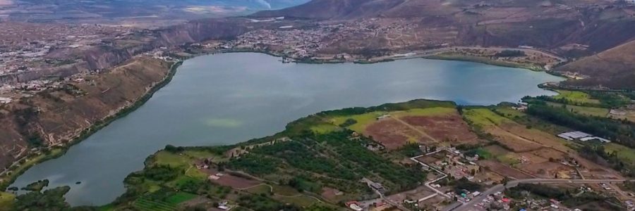
Echeverría-Almeida and Athens underwater survey of the Laguna Yahuarcocha (Lake of Blood) builds on earlier subaquatic research performed in the lake in the early 2000s.… Read More Investigación Subacuática en las Lagunas de Yahuarcocha (Review)
Citation Bray, Tamara L., and José Echeverría Almeida. “The Late Imperial Site Of Inca-Caranqui, Northern Highland Ecuador: At The End Of Empire.” Ñawpa Pacha, Journal of Andean Archaeology 34, no. 2 (2014): 177–99.
Bray, Tamara L. “Archaeological Survey in Northern Highland Ecuador: Inca Imperialism and the País Caranqui.” World Archaeology 24, no. 2 (October 1992): 218–33. Tamara Bray’s “Archaeological Survey in Northern Highland Ecuador: Inca Imperialism and the País Caranqui” documents the presence of local and Incan influences in the Guayllabamba basin, an area that represented the Incas’… Read More Archaeological Survey in Northern Highland Ecuador: Inca Imperialism and the País Caranqui: Bray
